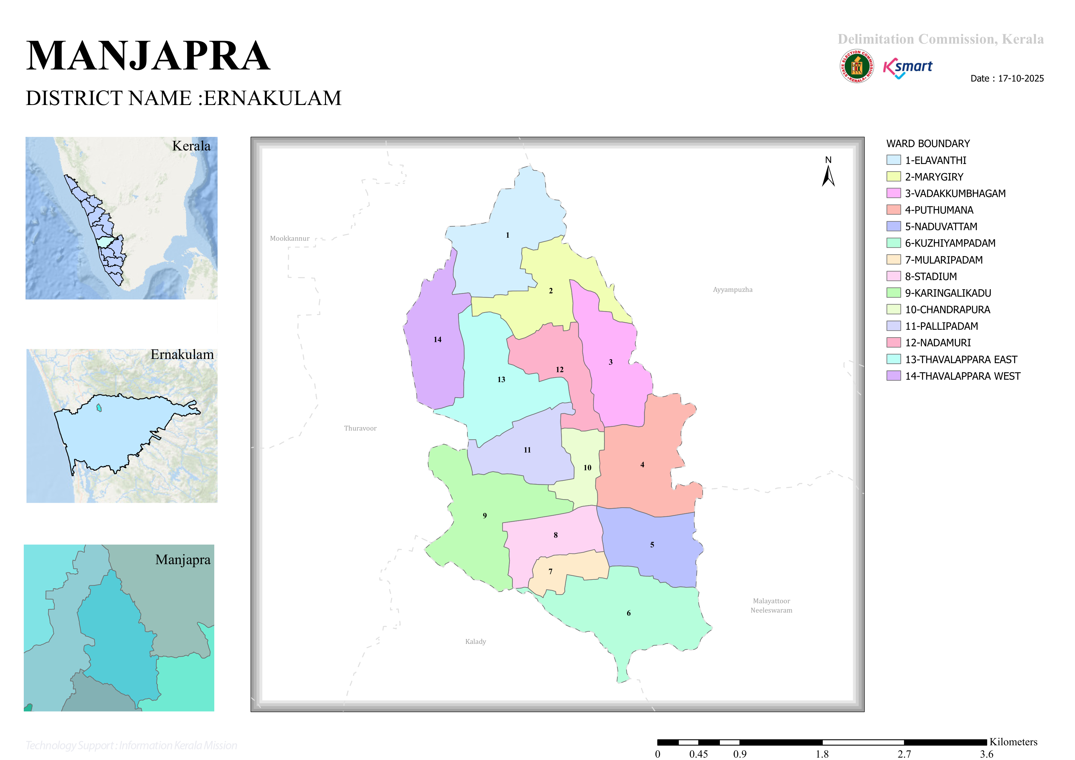
Map 2026
Manjapra Grama Panchayat – Final Notification Report on Ward Delimitation
1. Executive Summary
In accordance with the provisions of the Kerala Panchayat Raj Act, 1994, Manjapra Grama Panchayat in Ernakulam District has been reorganized into 14 electoral wards, with their boundaries finalized through an official delimitation process. The ward division was carried out based on the determination of 14 elected members for the Panchayat. Following the publication of the draft proposal, objections and suggestions received from the public were examined, and the final notification was subsequently issued.
2. List of Wards
| Ward No. | Ward Name | Population |
|---|---|---|
| 01 | Elavanthy | 1,244 |
| 02 | Marygiri | 1,162 |
| 03 | Vadakkumbhagam | 1,241 |
| 04 | Puthumana | 1,202 |
| 05 | Naduvattom | 1,190 |
| 06 | Kuzhiyampadam | 1,168 |
| 07 | Mularippadam | 1,038 |
| 08 | Stadium | 1,044 |
| 09 | Karingalikad | 1,044 |
| 10 | Chandrappura | 1,062 |
| 11 | Pallippadam | 1,244 |
| 12 | Nadamuri | 1,108 |
| 13 | Thavalappara East | 1,101 |
| 14 | Thavalappara West | 1,162 |
3. Population Analysis
Wards with the Highest Population
- Elavanthy – 1,244
- Pallippadam – 1,244
Ward with the Lowest Population
- Mularippadam – 1,038
Overall Statistics
- Total Population: 16,010
- Average Population per Ward: Approximately 1,144 persons
The distribution of population across the wards indicates that efforts have been made to maintain a reasonably balanced population, ensuring equitable representation throughout the Panchayat.
4. Key Features of Ward Delimitation
Ward boundaries have been delineated based on prominent physical and administrative features, including:
- Major roads,
- Canals,
- Streams,
- Bridges, and
- Existing Grama Panchayat boundaries.
The boundaries of the neighbouring Panchayats of Thuravoor, Kalady, and Malayattoor-Neeleswaram have also been considered in defining certain ward limits.
5. Administrative Significance
The finalized ward delimitation will serve as the basis for forthcoming Local Self-Government elections. By ensuring a balanced population across the wards, the delimitation is expected to:
- Strengthen democratic representation;
- Facilitate efficient planning and implementation of development programmes;
- Improve ward-level governance and public service delivery.
6. Conclusion
The final notification reorganizing Manjapra Grama Panchayat into 14 wards and defining their boundaries constitutes a fundamental administrative document for the Panchayat's governance and electoral system. The relatively balanced population distribution among the wards contributes to enhancing the quality of democratic representation and supports effective local administration and development planning.